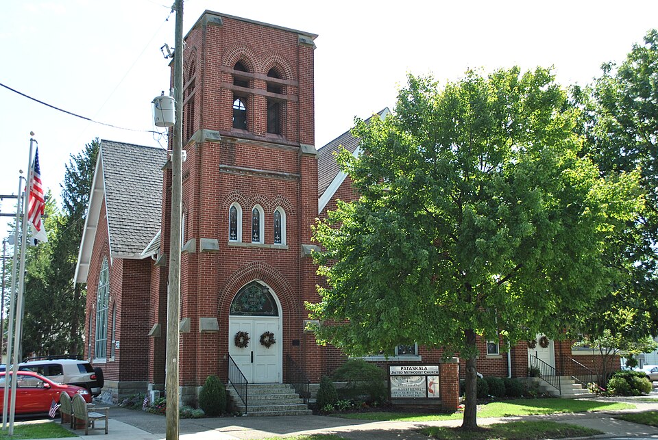
Listed on the National Register of Historic Places in
1983. A historic map-sheet match is not published yet. The record needs a coordinate-quality review before it can be joined to a sheet boundary.
From the record
“Pataskala United Methodist Church is a historic church building at 458 S.”
Wikipedia article Pataskala United Methodist Church, CC BY-SA 4.0.
one of 52 National Register listings in Licking County · listed in 1983 · category: Building.
National Register reference number.83001999- the number the National Park Service assigned this property when it was listed, and the key its nomination file is catalogued under at the National Archives.
Storms near this property
25 since 1997
Regional context, not property-specific
evidence. The National Weather Service names
Pataskala, the town this property stands in, in 25 storm reports between 1997 and 2017: 13 thunderstorm wind, 7 hail, 4 flash flood, 1 flood.
The reports record 1 injury. Each account below is quoted exactly as the forecast office
filed it, from the NOAA Storm Events Database, and each date
opens the federal record of that event.
Large hail to golf ball size fell for an extended period of time across the far western portion of the county, causing widespread significant damage. Thirty to forty mobile homes and numerous vehicles were severely damaged. A few subdivisions in the Pataskala area had homes that sustained extensive roof and siding damage.
A trailer park was flooded forcing several evacuations. A gravel parking lot flooded at National Trail Raceway near Kirkersville, trapping several automobiles.
No historic map-sheet match is published
for this property yet. That does not mean no map exists. This record needs
a coordinate-quality review before it can be joined to a sheet boundary.
Browse the county's mapped places while that work is
pending.
Named in the fire insurance atlases
Sanborn surveyors printed an index of the
town's establishments at the front of each atlas. This property is named in
one, read straight off the scanned sheet.
When this property was proposed for the
National Register, someone wrote the case for it: what the building is,
and why it matters. That document is a federal record in the public domain.
It is quoted below word for word, never summarised. The text was read off the scanned case file by machine, so the
occasional stray character is the recogniser's and the 1970s
typewriter's.
Description of the property
ruins resubmission excellent Category fair Date unexposed Ownership yes completeness AUG91983 alterations/integrity Status Reviewer deteriorated OHIO clarity Recom./Criteria Discipline RETURN Licking County ACCEPT Action: boundary selection MRA) Accessible Condition owner objection summary paragraph Reviewer's comments: Has this property been determined eligible? Substantive Review: Working No. Present Use Check one NR decision AUG REJECT good 8.
Statement of significance
(in one paragraph) Comments for any item may be continued on an attached sheet Other - Phone: _ LICKING COUNTY, OHIO ColumbusLandmarks Foundation Pataskala United Methodist Church PARASKALA HISTORIC RESOURCES Nancy Recchie North elevation 22 N. Front St. September, 1980 LICKING COUNTY, OHIO 22 N. Front St. Columbus, Ohio September, 1980 Pataskala United Methodist Church Columbus Landmarks Foundatio: Nancy Recchie Facade and south elevation PATASKALA MULTIPLE RESOURCES Please refer to the map in the Multiple Property Cover Sheet Reference Number:64000642 for this property Multiple Property Cover Sheet
Quoted from the National Register nomination
for reference 83001999, 8 pages, held by the National Archives in Record
Group 79. See the
catalogue record.
Listed places nearby
1 within 8 miles
Other National Register properties close
enough to walk or drive between, ordered by distance from this one. Both
positions come from the same geocoding pass that matched these properties
to their map sheets.
Listing record. National Park Service National Register of Historic Places, listed-properties dataset, current to 2026-05-22.
Map join. Address geocoded through the United States Census geocoder, then tested against the published boundary of every sheet in the USGS Historical Topographic Map Collection.
How this page is made. Listing fields come from federal records; map-sheet coverage is a labelled coordinate-to-boundary calculation, not a source-field claim.
Storms. NOAA National Centers for Environmental Information, Storm Events Database https://www.ncei.noaa.gov/stormevents/ A work of the United States government, no copyright under 17 U.S.C. 105. Narratives are quoted verbatim from the National Weather Service report and are not edited or summarised.
 Block
Block